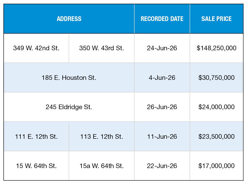

Detroit’s Demolition Program Now Has an Online Tracker Map
Residents can find out which vacant houses have been brought down and which are under contract for demolition.
By Alexandra Pacurar
Demolition Tracker Map
Detroit—In an effort to increase transparency of the blight removal program, the City of Detroit announced the launch of the Demolition Tracker map, an online tool which allows residents to see when and where vacant houses will be demolished. The app currently lists more than 9,500 residential buildings brought down since January 2014 and marked with blue dots. Units planned for demolition are marked with orange dots.
By clicking on each of these dots, users can find out the exact address, actual/anticipated knock-down date, the contractor selected through the competitive bidding process, and the cost for that particular demolition. Residents can also search for a particular property by introducing an address in the search bar. The map is constantly updated, so as soon as a structure is razed, the dot turns from orange to blue.
The Demolition Tracker map took over a year to be developed and it allows Detroiters to plan ahead for the lots that will be cleared of blight. Residents, or anyone interested in the information, can find out in up to 90 days in advance which vacant houses will be torn down.
This year, the city plans to take down 5,000 dangerous houses and 6,000 more next year. Detroit is deploying the nation’s largest demolition program, which has been awarded more than $250 million dollars by the U.S. Treasury Department and Michigan State Housing Development Authority, half of which in the last two months alone.
Image via City of Detroit/Esri